TRAVEL TO RUBI-KA


MAIN PAGE
WORLD MAP
IN-GAME MAP FILES
GRID MAP
WHOM-PAH MAP


4 HOLES
AEGEAN
ANDROMEDA
ATHEN SHIRE
AVALON
BELIAL FOREST
BOREALIS
BROKEN SHORES
CENTRAL ARTERY VALLEY
CLONDYKE
DEEP ARTERY VALLEY
EASTERN FOULS PLAINS
GALWAY COUNTY
GALWAY SHIRE
GREATER OMNI FOREST
GREATER TIR COUNTY
HOLES IN THE WALL
LUSH FIELDS
MILKY WAY
MORT
MUTANT DOMAIN
NEWLAND
NEWLAND CITY
NEWLAND DESERT
OLD ATHEN
OMNI-1 ENTERTAINMENT
OMNI-1 HEADQUARTERS
OMNI-1 TRADE DISTRICT
OMNI FOREST
PERPETUAL WASTELANDS

PLEASANT MEADOWS
ROME BLUE
ROME GREEN
ROME RED
SOUTHERN ARTERY VALLEY
SOUTHERN FOULS HILLS
STRET EAST BANK
STRET WEST BANK
THE LONGEST ROAD
TIR CITY
TIR COUNTY
UPPER STRET EAST BANK
VARMINT WOODS
WAILING WASTES
WARTORN VALLEY
WEST ATHEN


AO MAP LINKS
CONTACT


WORLD MAP


Click on the maps or the links below for a selection of viewable and printable sizes.

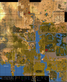
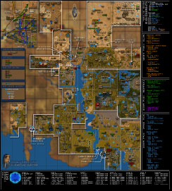
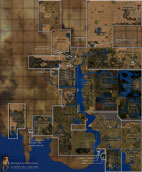
This is a very large map which provides incredible detail of playfield terrain and structures of Rubi-Ka, and includes:

  • Playfield borders with zone lines
  • Playfield names
  • Land Control Areas
  • Whom-Pah System routes
  • Grid Access Terminal locations
  • Public Grid Access requirements
  • Fixer Grid Exits
  • Playfield Locations in the Fixer Grid
  • Ferry Locations and Routes
  • Guarded Locations (outposts, guard posts, etc.)
  • Startup Backyard Locations
  • Carbonrich Rock fields and qualities
  • Labeled Points of Interest
  • Dungeons
  • DynaCamps
  • Amenities (bank terminals, insurance terminals, etc.)
  • Supermarkets
  • Vendor/shop general locations
  • Special Vendor locations

This map is also available as an IN-GAME MAP with supplimental Playfield Help Files.

COMPLETE OVERLAY
-
FULL SIZE (5.5MB)
- IN-GAME MAP


The following maps represent an overview of Rubi-Ka with:
  • Playfield borders with zone lines
  • Playfield names
  • Land Control Areas
  • Whom-Pah System routes
  • Grid Access Terminal locations
  • Public Grid Access requirements
  • Fixer Grid Exits
  • Playfield Locations in the Fixer Grid
  • Ferry Routes
  • Outposts
  • Carbonrich Rock fields and qualities
  • Labeled Points of Interest
  • Dungeons

The complete overlay with map background is also available as an IN-GAME MAP.

COMPLETE OVERLAY
-
FULL SIZE
- IN-GAME MAP

WHITE BACKGROUND
- FULL SIZE


The following maps represent an overview of Rubi-Ka with Playfield Names and Zone Borders.

BASIC OVERLAY
- PRINT SIZE
-
FULL SIZE

WHITE BACKGROUND
- PRINT SIZE
-
FULL SIZE


All contents of this site and designed graphics are © 2003, Nepentheim Design
Anarchy Online logo, symbol, map graphic, and in-game graphics are © 2003, FunCom
Contents of this site may not be reproduced or altered without permission.